I left Norseman at six o'clock in the morning to start driving east through the Nullarbor. This is an epic journey of about 1200 km to a town called Ceduna in the state of South Australia. My plan was to break the journey at the Border Village Roadhouse, about 720 km away. After leaving Norseman the drive takes you through semi-arid eucalyptus forests for a while, until you cross the Fraser Ranges, which may sound like mountains, but really are fairly shallow hills. Once you cross them you soon come to the 90 mile straight, Australia's longest straight; not that the rest of the road is exactly winding.
There aren't really any towns along the way, but the drive is dotted with roadhouses every 150 km or so. Each one of them usually has a petrol station, a restaurant and a few motel rooms and/or a caravan park. Water is very scarce, so you need to make sure to stock up in Norseman, the roadhouses sell it at a high cost. The petrol wasn't as expensive as it was in the northern passage that I took through Queensland, where it was over $2 a litre. One peculiarity is that each of the roadhouses has one golf hole. This is part of the Nullarbor Links, the worlds longest golf course spanning 1,365 km from Kalgoorlie to Ceduna. I am not a very experienced golf player, but the fairways looked pretty rough to me, and I suggest you were solid footwear if you attempt to play it.
I got to my Border Village Roadhouse mid-afternoon. The clocks go forward by 45 minutes east of the Caiguna Roadhouse to observe Central Western Australian Standard Time, an unofficial time zone that extends for about 340 km and about 100 meters across the South Australian border so that the Border Village Roadhouse is included. I had a motel room booked in one of their cabins, which was very basic, but clean. The beer in their bar was ice cold and the burger that I had for dinner was big. There were about a dozen other people in the bar, some road train drivers and some grey nomads, all enjoying the hospitality and watching the one-day cricket match between Australia and South Africa. I turned in at about 8.30 because I wanted an early start.
I set off at 5.45 AM ACWST, which meant that after driving 100 meters it was 7.30 AM Australian Central Time. After the border this is really where the Nullarbor Plain begins. It is the worlds largest exposure of a single limestone slab, and a dog's worst nightmare, there is not a single tree in sight. This is also where the Eyre Highway follows the coastline of the Great Australian Bight. There are four lookouts along the way where you can take in the cliffs and try and spot a southern right whale, at the right time of the year. I found the most eastern lookout the best, with the most spectacular 80 metre high cliffs towering above the ocean.
The Nullarbor Roadhouse marks the end of the plain when driving east. Soon afterwards the eucalyptus forests return and once you get past an aboriginal settlement called Yalata you will soon notice vast wheat fields. The first town you will get to is called Penong and then Ceduna. I decided to go past Ceduna and follow the coast for another hour to a small town called Streaky Bay, where I booked a room at the pub for a couple of nights. I got there at about four o'clock in the afternoon, finishing my Nullarbor crossing. I didn't think it was as epic a journey as you hear about. It probably was horrific when it was just a dirt road, but these days the road is one of the best ones that I have driven since I turned left in Townsville. The Barkly Highway felt the most adventurous outback road to me. It had a speed limit of 130 km/h, but I was rarely game enough to go faster than 100.
Anyway, I am writing this post from Streaky Bay, after a day of exploring the area. The town itself is very small and very friendly. Everyone I walked past in the street said G'day, even the children. The pub is quite charming. It has an old part and a modern annex. My room is in the old part, up on the first floor with a lovely verandah overlooking the sea.
The sights I took in today were all south of the town. The coast here is quite serrated with cliffs and capes forming many bays. I visited a few of them to bring you some pictures, but the highlights were Point Labatt, where the only permanent sea-lion colony of mainland Australia lives, The Granites, where I spoke to some local surfers and the Whistling Holes on Cape Bauer, where the swell blows air and water through holes in the limestone karst.
On my way back from Point Labatt I headed inland to see Murphy's Haystacks. They are a granite formation in the middle of a field. Apparently an Irish agricultural expert, who was travelling Australia to promote a technique for making hay, saw them from the highway and pointed out to the rest of his group on the coach that this farmer surely must have used his technique to get such a lot of hay. In geological terms the formation is known as inselberg (island mountain) where the landscape eroded around the rocks (I think Uluru is an inselberg too).
For the ones of you who are multimedia enabled, here are a couple of videos, one of a sea-lion going swimming and one of a whistling hole blowing water:
I haven't yet made up my mind how far I will travel tomorrow, probably to somewhere in the vicinity of the Clare Valley wine region. My plan is to get to Melbourne by the end of the week. I will most likely give Adelaide a miss because I lived there for a little while and know it quite well.
 |
| Just making sure you realise that it is going to be straight for a while |
 |
| And it is |
 |
| And this is what the more winding sections of the road look like |
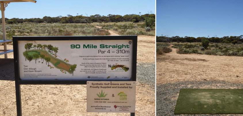 |
| The golf tee and fairway at Caiguna Roadhouse |
 |
| The cabins at Border Village Roadhouse (traveller's chapel in the foreground) |
 |
| This is the reason for the name Nullarbor, not a tree in sight |
 |
| Where the Nullarbor Plain meets the Great Australian Bight |
 |
| Not a good idea to go too close to the cliff edge |
Anyway, I am writing this post from Streaky Bay, after a day of exploring the area. The town itself is very small and very friendly. Everyone I walked past in the street said G'day, even the children. The pub is quite charming. It has an old part and a modern annex. My room is in the old part, up on the first floor with a lovely verandah overlooking the sea.
 |
| The Streaky Bay Hotel |
 |
| My blogger's office |
The sights I took in today were all south of the town. The coast here is quite serrated with cliffs and capes forming many bays. I visited a few of them to bring you some pictures, but the highlights were Point Labatt, where the only permanent sea-lion colony of mainland Australia lives, The Granites, where I spoke to some local surfers and the Whistling Holes on Cape Bauer, where the swell blows air and water through holes in the limestone karst.
 |
| Surfer at The Granites |
 |
| The Granites with High Cliff in the background |
 |
| A male sea lion at Point Labatt |
 |
| Point Labatt from the cliff above |
 |
| Whistling Hole at Cape Bauer |
On my way back from Point Labatt I headed inland to see Murphy's Haystacks. They are a granite formation in the middle of a field. Apparently an Irish agricultural expert, who was travelling Australia to promote a technique for making hay, saw them from the highway and pointed out to the rest of his group on the coach that this farmer surely must have used his technique to get such a lot of hay. In geological terms the formation is known as inselberg (island mountain) where the landscape eroded around the rocks (I think Uluru is an inselberg too).
 |
| Murphy's Haystacks |
 |
| Seen from the higway they could be mistaken. |
For the ones of you who are multimedia enabled, here are a couple of videos, one of a sea-lion going swimming and one of a whistling hole blowing water:
I haven't yet made up my mind how far I will travel tomorrow, probably to somewhere in the vicinity of the Clare Valley wine region. My plan is to get to Melbourne by the end of the week. I will most likely give Adelaide a miss because I lived there for a little while and know it quite well.
No comments:
Post a Comment