In my last post I promised that I will send a photo looking from the main range down the western fall to Geehi, as soon as the weather was good enough to get up there. I had to wait just over a week, during which it rained on and off and there was low hanging cloud, which restricted my walking to the lower areas of Thredbo. I managed to walk from the village up to the top on three different days, taking a different route each time. Yesterday I finally woke up to cloudless skies. After my daily intake of weet-bix I had a coffee on my balcony for a final weather-check before heading out.
I got to the bottom station of the chairlift just before 8.30, when I thought they would open. Unfortunately I was a bit over-enthusiastic, the lift doesn't open to the public until 9 AM, so if you plan to set out early for a walk in the main range you either need to walk to the top, or drive across to Charlotte's Pass. I spent the half hour soaking up the morning sun and watching the lift crew getting the chairs racked on to the lift.
For those of you that are not familiar with the Australian Alps, Mt Kosciuszko is the highest mountain in Australia. Even though the chairlift in Thredbo is called the "Kosciuszko Express" it doesn't actually go up it, but it takes about 600 vertical metres out of your journey to it. From the top of the chairlift there is an undulating walk to Rawsons Pass and from there you ascend to the actual Mt. Kosciusko. The walk between the top station and the foot of Mt. Kosciusko is about 5 kilometres, most of it raised on metal grids, which have a pleasant bounce that adds a spring to your step.
The raised walk way prevents erosion by the thousands of people who conquer Kosciuszko each year. It seems to work very well and you can enjoy unspoilt alpine flora all along the way; during December and January there are many wild flowers in bloom. About half way along the path crosses the headwaters of the Snowy River. If you have been following my blog, this is the river along which I drove down to the coast when I first started my trip around Australia, so I have now seen it in all stages of its being.
Just before you get to Rawsons Pass at the foot of Mt Kosciuszko you can see Lake Cootapatamba, which is the highest lake in Australia and one of only a handful of glacial lakes on the continent.
Once you get to Rawsons Pass you can take advantage of Australia's highest toilets, which have been built since I was up here last. Given the popularity of Mt Kosciuszko as a tourist destination it makes sense to provide facilities so that people don't get caught out and have to step behind a rock, because there are no trees up here.
I actually walked up Mt. Kosciusko only three days before this walk, on a grey rainy day, more for the exercise than the views. Yesterday my goal was first and foremost to go and take a picture of the western slopes, so I turned off the summit road, along the main range track, towards Muellers Pass with a plan to ultimately reach Mt Townsend, Australia's second highest peak.
I last walked up to Mt Townsend 22 years ago, when some friends wanted to paraglide down the western falls. I remembered that the track skirts around the south western flank of Mueller's Peak. Walking down the main range track to Mueller's pass I could make out the track in the distance, but once I got down to the pass there wasn't a discernible beginning. So I walked up the hill from the pass a little bit and then cut to the left, slightly downhill in the hope to meet the track further along. It worked and only couple of hundred metres in I found a small, but well recognisable track. It is easy to follow, until you get to a rocky ravine about half way across the flank of Mueller's peak. From there the track is marked with small stone cairns on the rocks.
I got to the little plateau at the foot of Mt Townsend after about 2 1/2 hours walking from the top of the chairlift. From here to the Summit you have to scramble across rocks. If that is not your thing, you can minimise the climbing and skirt around the peak, still getting great views in all different directions.
Before heading back I took a little detour towards Alice Rawson Peak. This is definitely worthwhile for the views of Lake Albina and Watsons Crags, where the Main Range looks its most rugged.
On the way back I somehow missed the track and got a bit too far down into Wilkinsons Valley between Mt. Townsend and Mt Kosciusko. On a sunny day with clear visibility that is no drama, as you are never really lost, there are plenty of visible landmarks, and I simply headed towards Mueller's peak until I picked up the track again. I took a panoramic picture from Wilkinsons Valley that includes Kosciuszko and Townsend. It didn't turn out very well, but the reason I mention it is that back on the main range track there was a wedgetail eagle soaring only about 50 metres directly above me. I reached for the camera, turned it on and it started preparing itself for another panoramic picture.... by the time I changed the setting the eagle was gone, so sorry, no picture of rare birds!
Once I reached the summit road I figured that to round off my blog post for you I might as well take a picture of Mt Townsend from Mt Kosciuszko, so I turned right and walked up to the summit. As can be expected on a perfect day, there were crowds gathering, almost queuing to take their selfie with the trig marker as proof that they conquered Mt. Kosciuszko. I only stayed long enough to get the opportunity of taking a picture of Townsend without someone standing in front of it and then headed back to Thredbo.
To finish this post I want to show you some of the alpine flowers that you can expect this time of year and a picture of the Ramshead Range, which is my next project for an alpine ramble.
 |
| Weather check from my balcony, not a cloud in sight! |
 |
| Bottom, middle and top of the chairlift journey |
 |
| The iron walk way, with a first glimpse of Mt. Kosciuszko (the middle one) |
The raised walk way prevents erosion by the thousands of people who conquer Kosciuszko each year. It seems to work very well and you can enjoy unspoilt alpine flora all along the way; during December and January there are many wild flowers in bloom. About half way along the path crosses the headwaters of the Snowy River. If you have been following my blog, this is the river along which I drove down to the coast when I first started my trip around Australia, so I have now seen it in all stages of its being.
 |
| A pretty brook |
 |
| Turns into a powerful mountain stream |
 |
| Calming down near the coast |
Just before you get to Rawsons Pass at the foot of Mt Kosciuszko you can see Lake Cootapatamba, which is the highest lake in Australia and one of only a handful of glacial lakes on the continent.
 |
| Lake Cootapatamba at the foot of Mt Kosciusko |
I actually walked up Mt. Kosciusko only three days before this walk, on a grey rainy day, more for the exercise than the views. Yesterday my goal was first and foremost to go and take a picture of the western slopes, so I turned off the summit road, along the main range track, towards Muellers Pass with a plan to ultimately reach Mt Townsend, Australia's second highest peak.
 |
| I turned right along the Main Range Track |
 |
| There should be a track to the left somewhere here... |
 |
| That's what it looks like once you find it |
 |
| Can you see the cairn marking the track? |
I got to the little plateau at the foot of Mt Townsend after about 2 1/2 hours walking from the top of the chairlift. From here to the Summit you have to scramble across rocks. If that is not your thing, you can minimise the climbing and skirt around the peak, still getting great views in all different directions.
 |
| The summit of Mt Townsend |
 |
| The view down the western fall. The grassy area in the back is Geehi, only 8 km away, but 1700 metres lower |
 |
| The view east, across to Mt. Kosciuszko |
 |
| Lake Albina |
 |
| Watsons Crags |
Once I reached the summit road I figured that to round off my blog post for you I might as well take a picture of Mt Townsend from Mt Kosciuszko, so I turned right and walked up to the summit. As can be expected on a perfect day, there were crowds gathering, almost queuing to take their selfie with the trig marker as proof that they conquered Mt. Kosciuszko. I only stayed long enough to get the opportunity of taking a picture of Townsend without someone standing in front of it and then headed back to Thredbo.
 |
| Kosciuszko Summit |
 |
| Mt Townsend from the summit |
To finish this post I want to show you some of the alpine flowers that you can expect this time of year and a picture of the Ramshead Range, which is my next project for an alpine ramble.
 |
| Billy Button |
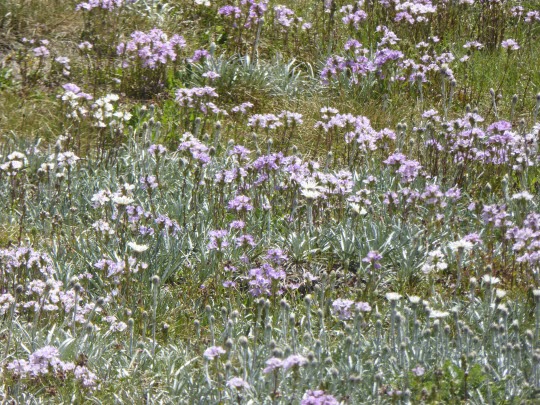 |
| A field of wild flowers |
 |
| The Ramshead Range (4th highest in Australia) |
No comments:
Post a Comment