Friday, 31 October 2014

Karratha

Karratha is about 850 kilometres south west along the coast from Broome. There isn't much along the way until you get to Port Headland, which is very busy with trains, road trains and all sorts of other mining related vehicles. It appeared to me like Port Headland was dominated by BHP, judging by some of the road signs. I didn't stop and pressed on towards Karratha, but got only as far as Roebourne, where I got into my first traffic jam since I left Sydney weeks ago. The reason was that the highway was closed because of a bush fire. I waited in the queue for about 1/2 hour just outside town, but then decided I might as well use the time to have a bit of a look around. I went to the tourist information office, which is housed in the old Roebourne Gaol. The lady looking after the place gave me a map of the area and explained for about 20 minutes what I should have a look at during my stay in Karratha. Basically Karratha itself is a service town for the mineral and gas industry in the area, so it is the surrounds that are really of interest. I decided to fill my three days by exploring the north of Karratha on day one, the south on day two, and take a cruise around the Dampier Archipelago on day three. 

Old Roebourne Gaol Museum and Tourist Information


Because the road was still closed, I took a closer look around the old gaol, which now serves as a museum for the town of Roebourne. I learned that Roebourne was first settled by sheep farmers back in 1864. Apparently there was a law that convicts couldn't be put to labour north of the topic of Capricorn, so the first settlers "persuaded" the local Aboriginals to sign work contracts. There was another law that when an employee broke their work contract he could be pursued, jailed and put to hard labour as a prisoner. Because many of the press-ganged workforce didn't actually understand what they got themselves in for, many of them ended up as working prisoners in Roebourne gaol. The sheep farmers took to pearling in the off season, and soon the pearling trade started to flourish in the area, until it moved north to Broome about 20 years later. 

Once a prisoner was put in chains they stayed on for the duration, 24x7
It took about two hours before they re-opened the highway. There was a section where the fire was still encroaching on the road, and as with all the spinifex grass fires that I have driven through over the last couple of weeks, the heat was bearable, but the smoke really affected visibility.

Driving through the bush fire area

I arrived in Karratha just as the sun set. The place where I stayed was a donga in a workers camp outside of town in an industrial estate and still more expensive than the one bedroom apartment with sea view that I had in Broome. This is the Pilbara region for you. It is still booming with mineral and gas exploration. Like Port Headland was dominated by BHP, so is Karratha dominated by Rio Tinto and Woodside. The town was only started in the eighties when the town of Dampier got too small for all the new industries. Driving through Karratha reminded me a bit of Canberra. Lots of high density suburbs with houses right up to the edge of their block and a huge shopping mall in the centre of town.

On the first morning I got up at 5 AM, because everyone else did and they reversed their trucks out of the car park, beep... beep... beep. I drove back to Roebourne, which is north of Karratha and then turned left towards Point Samson. Roebourne is inland, and its first port was a town called Cossack, which was also the first port of call of my tour on day one. Cossack is no longer inhabited, other than by a couple of caretakers. Yet many of the old buildings still exist and tell the story of past times. I spent a couple of hours looking at the sites, taking in some of the old buildings, a couple of lookouts, settler's beach and the cemeteries. There are two of them, one for the Europeans and one for the Japanese that came with the pearl industry. The grave for the oldest person that I could find was 65 years, most of them died in infancy or at the age between 40 and 50; it must have been a tough life. One grave was that of a girl that died from tetanus after standing on a rusty nail in the school yard (I read the story at the school house and then found the grave later).

Cossack Court House

Inside one of the old stores

Laura died aged 10 after standing on a rusty nail
Cossack only had a short live. The pearl industry moved north to Broome, the harbour got too shallow for the larger vessels and to top it all off it got devastated by a cyclone. In 1910 a new port was opened in Point Samson, which is where I went next. Point Samson is a small town with a pub, a general store, a couple of bed & breakfasts and two large caravan parks. It has a small boat harbour and you can still see some remains of the old jetty that replaced the port of Cossack. However, if you go up to the local lookout you can see the new port, just north of the town where they load huge iron ore carriers.

Point Samson Pub (nice veranda)

Remains of the old jetty
After Point Samson I drove through the town of Wickham to the other side of the peninsula, getting closer to the new port. Unfortunately you can't actually see the port, but you get close enough to see the section where they unload the trains onto the iron ore stockpiles that are then shipped to China. It was good to see a train up close to see how big the carriages were, because on the previous day I was stuck on the road next to the railway and counted a train with 200 carriages. It must have been almost 2 km long.

Iron ore stock pile at the port

Iron ore carriages
On the way back from the port I stopped in Wickham and bought some bait and then headed back to Cossack to try my luck with the local sea life. I first did some beach fishing near the cemetery, where my bait was mainly eaten by mud crabs. Then, when the tide was high, I moved to the old Cossack Wharf and there it was an absolute feeding frenzy. I caught a sergeant major fish, which is no good for eating, and then got a large queen fish, but it broke the line before I could land it. I was only using a hand line, with  which I need to practice a lot more.

Cossack Wharf at low tide (high tide was 5 meters higher)
On day two I decided to explore the south of Karratha, where you find the town of Dampier and the Burrup Peninsula. I started by driving towards the Burrup Peninsula, but then taking the first right towards Hearson's Cove. The lady at the Roebourne tourist information told me to go to Deep Gorge, which is on that road, and take a look at the aboriginal rock carvings. There were no signs to Deep Gorge, but I found the car park that she mentioned and started to walk into what I perceived to be the gorge. After about a kilometre I met an English couple who were also looking for the rock art and couldn't find any. They had a rudimentary hand drawn map showing where to look, but they said that they walked to the end of the track without success, so turned around. I kept on walking to the end of the track and noticed that there was a faint track following the valley further up, so I decided to march on. At the end of the valley I got over a ridge and a new valley opened up, with views right down to Port Dampier. From the map that they had I remembered to look out for a pile of shells, where the tribes used to feast, and I did find a sizeable mound of shellls about another 20 minutes into the second valley. On a rocky heap near the shells I saw what I took to be some rock art, so decided to take a picture and turn around because it was getting very hot and I was about an hour's walk away from the car park, with no one else around. When I returned to the car park the English couple were still there, saying they got worried about me and decided to wait for my return. Good to know that there are people who care! They also told me that we were looking in the wrong place and that the rock art only just about 200 metres around the corner from the car park. I did go to take some more pictures, but I was still proud to have found some rock art that was a lot more remote.


Where do I start looking for rock art?
Near the sea shells in the desert
Not much, but it looks man-made, and I found it by myself

Some of the rock-art where I was supposed to go (near car-park)
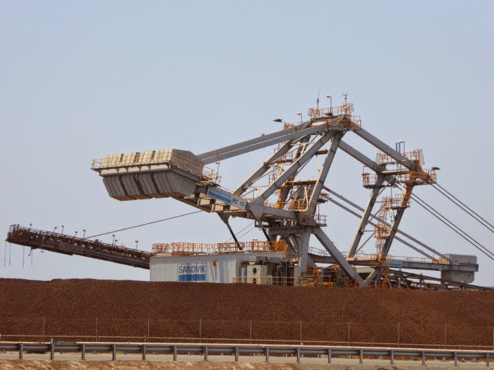
After my 2 1/2 hour excursion into the desert I was quite hot and needed to cool down, so I drove to the North West Shelf Project visitor centre, which I assumed would be air conditioned. And it was. A very friendly lady bade me welcome and took me to an auditorium where she played a movie that explained all about the North West Shelf Gas Project to me.It was started back in the eighties by Woodside, and these days is a collaboration of Woodside, BHP, BP, Shell and Chevron. It drills down into the sea bed about 135 km off the coast and collects gas and some oil. It accounts for over 40% of Australia's oil and gas production. The visitor centre was located on a hill overlooking the gas processing plant, from where gas is transported overseas via ships and down to Perth via pipeline. The numbers were staggering and the plant was huge. The total investment is something like 27 billion dollars so far. Anyway, it was air conditioned and I soon cooled down enough to go and have a look at the town of Dampier.

Part of the gas processing plant
Just before you get into Dampier you will find the memorial to the red dog, who is a legend in this region. Apparently he is buried somewhere between Dampier and Roebourne in an unmarked grave. If you don't know the story I strongly recommend that you get your hands on the movie (it will bring tears to your eyes).

Red dog memorial
Dampier itself is not that exciting. It has a large bulk shipping port from which Rio Tinto sends salt an iron ore around the world. Apparently Rio Tinto started as Dampier Salt Ltd., and there is a lookout sponsored by them from which you get a good view over the port, with the iron ore and salt stock piles in the distance, waiting to be shipped.

Salt stock piles at Dampier Port
I needed to post a letter to Switzerland, so I drove into the town centre to look for the post office. There wasn't one and the rest of the town centre was equally deserted. The life really happens in Karratha these days. After I posted my letter (in Karratha) I drove back to Hearson Cove to spend the afternoon at the beach.

Hearson Cove
The third day in Karratha I was planning to cruise around the Dampier Archipelago. There is only one tour provider, called Discovery Cruises. Both the Roebourne and Karratha tourist information told me to call the skipper directly, which I did repeatedly, but I always got the message bank, and he never replied. Either he must have sunk, or was not interested in doing business, with the result that I can't report to you on his activities. Because there really wasn't anything else to do in Karratha I cut my losses and headed off towards Exmouth on the third day.

Wednesday, 29 October 2014

Broome

Soon after leaving Halls Creek the landscape changes into large plains, rather than the hilly country of the East Kimberly. There aren't many towns along the way, other than Fitzroy Crossing. From Fitzroy Crossing you could take a scenic drive to Derby via the Tunnel Creek National Park, but I didn't think I had the time, so I went straight ahead on highway number 1. Nonetheless, once the highway hit the Derby to Broome road at a T intersection I turned right towards Derby, rather than heading straight for Broome. It was only 40 km away, so I thought it would be worth having a look. The town itself was nothing spectacular, so I kept going through it until I hit the end of the road. This was at the Derby wharf. Derby has the largest tides in Australia with a change of 10+ metres between low and high tide. It was close to high tide when I was there, so there weren't many mud flats to be seen. I had a very good cappuccino at the Wharf Cafe, which was very pleasant, despite the almost 40 degree temperature, because it gets a nice cooling sea breeze.

On the way out of Derby I stopped at their version of a Prison Boab. It is probably more famous than the one along King River Road in Wyndham, but it is also right next to the highway, so you don't have to go out of your way to see it. I liked the shape of the Derby Boab, but I still prefer the one in Wyndham, because of its remoteness and because there is written evidence that it was used as a lock-up, which there isn't for the one in Derby (according to my research on the Web).

Very pleasant veranda at the Derby Wharf Cafe

Derby Prison Boab
On my first morning in Broome I got up at the crack of dawn because low tide was at 5.30 in the morning and low tide is the only time when you can see the dinosaur footprints at Gantheaume Point. I got there just at low tide and made my way down the rocks to try and find them. There is neither a marked path down the rocks, nor any signs of where to find the imprints. Luckily there were some other people there, so we could cover a larger area in our search. We found two types, one was a set of smaller prints of a more bird like foot, the other was larger, with claws.

Dinosaur Footrpints
I found the surrounds of Gantheaume Point much more fascinating than the footprints. The Western Australian coastline is very different to the east coast of Australia. It reminds me of the following lines from the song 'A horse with no name':

After nine days I let the horse run free
Cause the desert had turned into sea...

It literally goes straight from desert to sea here, there are none of the lush green hinterlands that you have all up the east coast, and Gantheaume Point has beautiful red rocks that shone in the rising sun against the deep blue sea. 

Where the desert turns into see

Just a couple of kilometres north from the point starts Cable Beach, which is another claim  to fame for Broome. It is a perfect sandy beach, interrupted only by one band of rock, so you have 'south of the rocks' and 'north of the rocks'. North of the rocks you are allowed to drive your car on the beach and you are allowed bathe in the nude. I did neither of those, but I walked barefoot on the white sand for over 2 hours.. Because I usually don't walk barefoot this must have used some different muscles, and I had quite sore legs that night. There are also camel rides available on the beach. It runs for many kilometres up north until you reach Willie Creek at the northern end.

The white sand of Cable Beach
After my walk I drove out to Broome Port to have a look at the wharf, which is very long, because Broome also has large tides, second only to Derby. There were a few guys fishing along the walkway on the wharf and just as I approached one of them got a bite. It was quite a battle for him and the fish was so large that he had to use some special contraption to lift it from the water up onto the wharf. The fishing line would not have held the weight. He used a thing with three metal claws, attached to a long rope. The claws tightened around the fishes head as he lowered them down and he could lift it up, like a crane. I had a bit of a chat to him and to some of the other guys further along the wharf. All of them were in Broome for construction work and used fishing as a means to pass their time off on a Sunday. I guess if someone asks "what did you do on Sunday?" it is more acceptable to say "fishing" than "sat at home drinking beer", even though for some of them the beer consumption seemed to be equally as important as the fish.

A serious fish caught from the wharf

On my way back into town I stopped off at the Historical Society Museum. This is a little gem on the outskirts of Broome. Entry fee is $5 and you can easily spend an hour or two looking at the exhibits. It covers many aspects of the history of Broome, from the early days of pearling to the second world war with the Japanese raid on Roebuck Bay, and the development of communications.

After the museum visit I parked at the tourist information and walked a heritage trail through the old town centre, called China Town. It has many of the old buildings still intact, including an old jetty where the pearl luggers used to unload their harvest. The pearl industry was (and still is) dominated by Chinese and Japanese, hence there is a large Asian influence in the north west of Australia, evident in some of the architecture and by the Asian cemeteries in the various towns.

The old jetty

Broome Chinatown
One of the buildings that stood out to me was the Sun Pictures Cinema. It is almost 100 years old and is an outdoor screen. When I took a picture of it in the afternoon I noticed that there was a 6.30 PM session, so I decided to attend it, directly after taking sunset pictures at cable beach, which is a must for every Broome visitor. The sunset was nice, because the sun sets into the sea here on the west coast, and I took numerous pictures. Then I headed off to the cinema. Once you enter it, it is basically a large shed with a tin roof, with the north facing wall missing. About 20 meters in front of the shed is an outdoor movie screen. The seating is deck chairs. There were only about 10 other people, so I selected the last row of deck chairs still under the roof. This gave me the best of both worlds, the nice cooling air generated by the ceiling fans and the view of the starry sky above the screen. The movie was called "The Equalizer" and not very good, but the experience of Sun Pictures was worth it.

Sun Pictures Front
Deckchair Seating and Outdoor Screen

Broome was founded in the late nineteenth century as part of the growing pearl industry. Well, it wasn't really pearls that were at the heart of the industry, but the mother of pearl, which was used to make buttons. The area around Broome had Pinctada Maxima oysters, which grow much larger than other oysters and are therefore more economical to harvest and process. At the turn of the 20th Century Broome supplied about 85% of the mother of pearl in the world. With the invention of plastic the mother of pearl market collapsed, so these days it is the actual pearls that provide the income. Broome has several pearl farms in its surrounds, so on my second day I took the 40 km drive out to Willie Creek Pearl Farm, who do tours for tourists. The drive in itself was interesting because it started out on very sandy red roads, which very suddenly turned into white limestone once you get out on the flood plains. On the flood plains I encountered two horses, which I assumed were wild because there weren't any fences anywhere along the way.


The drive started in red sand...
...and suddenly turned into white limestone
A wild brumby on the way to Willie Creek


The most interesting part of the tour was the lecture on the anatomy of the oyster, how it is used to farm oysters and how the pearls are graded for value. Afterwards we got some drinks and home made damper before we took to Willie Creek in a boat to look at some oysters in the water. The oysters that they showed us were basically in retirement and only there for the tours. The commercial oyster farm is further out at sea and the location kept secret to prevent theft. We learned that each oyster is valued at 10,000 dollars over its lifetime; it can be seeded to produce pearls four times. Each oyster is manually implanted a seed cut from a Mississippi Shell, an then placed in a cage that holds 10 oysters. Then they are put into tanks for  a couple of months before transferred into the ocean, where they need to be turned and cleaned every 2 to 6 weeks, depending on the season. The whole process and maintenance is very labour intensive, and provides the holiday money for lots of backpackers. Naturally the tour ended in the pearl shop, where we were shown some examples ranging from $800 to $30,000. It was easy for me to resist temptation because I prefer black pearls, which are not grown in Australia.


I can now name every part of the anatomy, just ask me...

Oyster cages in Willie Creek

After the drive back into town I had some bank business to do to complete the purchase of my new home in Thredbo, and then I took on the hard task of visiting Matso's. I know that some of the Canberra audience of this blog are into boutique beers, and Matso's is a boutique brewery in Broome, and just by chance was straight across the road from where I stayed. You can take brewery tours, which include a tasting of the various brews in little glasses, but I took it on myself to taste the beers in their natural environment to be able to report to you as factual as possible.

Matso's Bar
Matso's Veranda

Matso's Beer

Matso's is one of the old buildings in Broome and has a lovely veranda all around it. They also serve food, which looked very good, but was not in my budget. BTW. happy hour is from 4.30 to 5.30 when the beers are only $6 instead of $8, so a good time for an afternoon tasting. My preferred beer was the Pale Ale, followed by the Smoky Bishop. I also tasted the Session Ale, which I found a bit too bitter and the Mango Beer, which I found too sweet.

On that note I finish the post from Broome and you will next hear from me from Karratha, about 850 km south-west from here.


Friday, 24 October 2014

Halls Creek

I got to Halls Creek early on Thursday afternoon and just as I pulled up at the Bureau of Meteorology (BOM) station a weather balloon took off from behind the building. I watched it rise and slowly move south east. I walked around the building and saw my friend David Murray behind some contraption that is used to manually track the balloon. Once he had finished his tasks he bade me inside the station and explained the intricacies of making the weather to me. 

Halls Creek BOM Station
It is a radar tower, not a minaret


David and I used to work together in the snow making department in Thredbo about 20 years ago. Now he is in charge of the weather station in Halls Creek. This is a job with a lot of responsibilities and requires a great degree of accuracy and timeliness. After all, the data collected is used to inform pilots of the weather, in addition of working out forecasts and measuring climate change. There is a beeper that comes on every half an hour reminding David to log his observations that he gathered over the past half hour, which includes stepping outside to watch the clouds and scan the horizon for dust devils. About an hour later David went to another section of the station, further away from the building, to take readings of evaporation rate, air temperature, ground temperature and underground temperature. I can report that the air was 39 degrees Celsius, the ground surface was the same, but, to my surprise, even one metre underground it was still a hot 35 degrees. David explained to me that technically Halls Creek has too much annual rainfall, with an average annual rainfall of 530 millimetres, to be classified as desert, but because of the high evaporation rate of about 3 metres per year there is a great deficit that creates the desert conditions.

David making the weather

After David knocked off for the day we went to his house, which he gets as part of the BOM job. It is very large, with a sizeable garden in which he grows all sorts of veg and herbs. I settled into the guest room, while David went off to hospital to get a minor procedure performed; if you want the gory details visit his facebook page... When he came back he was too sore to go out, so we had dinner at home. 

On Friday morning I got up at 5 AM and had my breakfast in David's garden, watching the various birds that he attracts with his plants. Once we were all fed and watered David took me for a tour of the local Halls Creek attractions in his 35 year old Subaru, that has a proud 437,000 kilometres on the clock.

Unbreakable (both of them)
We left Halls Creek on the Duncan Road, formerly known as the Duncan Highway. After about 15 km this takes you to Old Halls Creek, the site of the original town before it was moved closer to the air field. There is not much remaining. The street signs are still there and the spots where the businesses were are marked with rock cairns and plaques (if they haven't been stolen). The only building that still partially exists is the old Post Office. It is now protected with a tin roof over the top and a chicken wire fence around it. The buildings were all built from Adobe, made from mashed up termite hills and spinifex grass. This is not a material that stands up to wet weather very well, so when the tin roofs were moved to the new town the remaining walls of the old town soon deteriorated into oblivion.

Ruins of Old Halls Creek Post Office

From Old Halls Creek David took me "along the back way" to Lake Komatpillar; the name is apparently the combination of the Komatsu excavator and Caterpillar bulldozer that were used to build the dam. The back way took us first to an abandoned open cut gold mine with a lake at its bottom. 

Disused gold mine
After that we kept going past several "Danger Keep Out" signs further towards the lake. The track was quite rough, but David and his trusted Subaru navigated it with great skill and determination. Here is a short video showing how to navigate a hole despite limited ground clearance:

We arrived at the lake at about 9 o'clock in the morning and it was absolutely stunning. It is a perfect place to set up camp, swim, canoe and generally chill out. Because David was still rather sore after his operation, and not allowed to get his wound wet, he was restricted to only getting his feet wet. I took some photographs for you before we headed on to our next attraction.

Scenes from Lake Komatpillar
The next stop was Sawpit Gorge, which you can see from a long way away on the Duncan Road. It is a popular camping spot and while we were there a couple arrived with their four wheel drive and camping trailer to set up camp for a day. David and I moved on to what he calls the "secret water hole". This is a small water hole not far from Sawpit Gorge, in a small hidden valley, covered by trees and crystal clear water. This is where we stopped for a break and I had a refreshing dip.

Sawpit gorge from afar...

...and close up

Taking a dip in crystal clear water out in the desert

After our break we headed back towards Halls Creek, stopping off at Palms Spring, a spring that runs year round into a water hole that is surrounded with an ancient species of palm. Nearby is a small swampy area that in the times of the old town was used to house a market garden. We explored the old buildings there and found some fruit growing on trees that we didn't recognise. I cut one in half and licked it. It tasted very sweet, but I wasn't brave enough to eat it. If anyone knows what it is, please let me know.

Does anyone know what this is?

Palms Spring

Closer to Halls Creek we visited yet another water hole, which was the most ordinary of all the ones we visited, so I already forgot its name and I didn't take any pictures. However, we did visit another local attraction called the China Wall. This is a wall of large quartz rocks that runs along a north/south ridge. Because the quartz is harder than the surrounding rock it doesn't erode as quickly, which led to this spectacular formation, which almost looks man made.

China Wall (each boulder is about as high as a person)
When we got back into town we went to the shops and I took up the challenge laid down by the butcher shop. As I sit here and write this post there is a fatty, tasteless leg of lamb in the oven, trying to be turned into a tasty roast dinner, one of which I haven't had for over three months because no of the places I stay in on my travels has an oven.

A powerful marketing message
Tomorrow I will continue on my way around Australia and drive to Broom, which means getting back to the coast after two weeks out back.