Wednesday, 31 December 2014

Happy New Year

Another year ticks over, and with it the first six months of my gap year come to an end. I spent New Year's Eve at the Thredbo Village Square, where people gathered to have a few drinks, party and listen to a live band. The band was quite good and played a lot of well known songs for people to sing along and dance. I stayed until about half past midnight, which is a great improvement from the previous year, where I spent the evening at home and fell asleep on the sofa together with my two dogs.

Party in the village square
When I woke up at 7 am this morning I felt a little bit guilty for drinking several cans of rum and coke, which doesn't fit all that well in my "get fit" regime, so I decided to do some uphill walking to work them off. I walked from home up to the top of the Cruiser Chairlift, which is the eastern most lift in the resort, and then kept going until I reached the high plateau behind the ridge from where you can see across to Mt Carruthers and Mt Twynam. There was no one else about and I enjoyed the peace and quiet among some lush fields of wildflowers. 

Lush fields of wildflowers

View east towards Lake Crackenback Resort with Mt Crackenback
in the background
I then followed the ridge towards the middle slopes and took some pictures of the Village from some more unusual angles, before walking down the Merrits Nature track. I have been breaking in some new walking boots over the last few days and have some deep blisters on the right foot. Today I decided to revert to my trusty old Red Backs to give the heel some time to heal; I will try the new boots again, once I have some skin back.

View of Thredbo Village
Blue shoes are giving me blisters

As you can see


Tuesday, 23 December 2014

Rise above it!

The last couple of days we had some heavy rain and thunderstorms here in Thredbo, keeping me indoors reading my books. Last night the setting sun illuminated the last of the storm clouds with a red glow, giving me hope that today would be a clear day, you know "red at night, sailor's delight" and all that sort of stuff...

Last night's weather check from the balcony gave me hope
But when I got up this morning the day was damp and grey. I thought that it was raining, but it was only moisture from the trees dripping onto the tin roof of my living room. The balcony weather check revealed that there was no mountain and the village was shrouded in fog. 

The mountain is hidden in fog
I haven't had a decent walk in three days, so I decided to head up the mountain anyway, in the hope of it clearing up later. I stuck to the lower slopes and headed up the maintenance road to Merrits restaurant and from there up to the top of the Gunbarrel chairlift, where I took a break to cool down after the steep ascent. As I was standing there the fog started to clear and I caught a glimpse of Kareela Hut across the other side of the slopes. It was revealing itself from clouds like it was on an island. Within minutes the sky above me started to turn blue and I was bathed in sunshine. The village below still hid itself in the fog and I was glad that I made the effort to rise above it.

Kareela Hut making an appearance out of the cloud


Followed by the whole top of Crackenback

While the village remained hidden in the fog below

Saturday, 20 December 2014

Mt Twynam, only third highest, but the best views

Yesterday I returned to Charlotte's Pass to take a walk up to Mt Twynam, which is about 9 kilometres away along an easy to find route. You basically walk along the main range track in an anti-clockwise direction until you reach the pass below Carruthers Peak, where you take a sharp turn to the right and walk up along the ridge in the opposite direction to the main range track. There is an easy to identify track that was used by the Soil Conservation Service when they stabilised the slopes of Mt Twynam to stop erosion and the silting up of Blue Lake below. 


The Soil Conservation track is easy identifiable all the way

Looking back down to the saddle with Carruthers Peak behind it
Along the way to Mt Twynam you get good views either side of the ridge, but nothing like the views from the top. Because it is the third highest mountain in the range, and set apart a few kilometres from its colleagues in the "high league" you get uninterrupted views in all directions, with a splendid display of the highest peaks towards the south-west. I tried to name them all for you in a couple of my photographs (the green ticks are the ones that I have walked to over the last couple of weeks and published photographs in earlier posts).


Left of Kosciuszko

Right of Kosciuszko
Of all the summits I climbed so far I spent most time on Mt Twynam. The weather was perfect, with hardly a breath of wind, and the views in all directions made me feel on top of the world.


The trig point on top of Mt Twynam

The view towards Guthega and Blue Cow

The view towards Charlotte's Pass with Headly Tarn in the foreground

The view to Mt Jagungal and the ACT ranges
The one thing that you can't see from the summit of Mt Twynam is Blue Lake, which is directly at its foot and hidden by an outcrop above the steep rocky cliffs that fall down to the lake. On the way back to Charlotte's pass, along the same track, I took the short detour down towards the lake to take a picture with Mt Twynam in the background. The difference in elevation between the lake and the top is about 250 metres.


Blue Lake, backed by Mt Twynam and Little Twynam
Having done all these walks since I got to Thredbo seems to have had some benefits for my fitness. I dreaded the steep ascent from the Snowy River up to Charlotte's Pass at the end of the walk, but I didn't have to pause once and hardly raised a sweat.


"Heart Attack Hill" was easier than I expected

Tuesday, 16 December 2014

Name the lakes

Today I did the Lakes Walk. Well, that is what it was called in the past anyway; these days it goes by the name of Main Range Track. It is a 20 km loop walk from Charlotte's Pass to Mt. Kosciuszko, one half along the ridge of the main range, the other half along the old summit road. You can do the walk from Thredbo, you just need to add another 12 km to the length by walking from the top of the chairlift to Rawsons Pass and back. I wasn't sure whether I would be up for 32 km at this stage of my "get fit" programme, so I drove to Charlotte's Pass. 


You have the choice of doing the loop clockwise or anti-clockwise. Which direction you choose depends on whether you like short very steep inclines or longer steep inclines. If you go anti-clockwise you walk the more picturesque half first, but you have two long climbs, first up Mt Carruthers and then the Kosciuszko north ridge. Going clockwise you do the 9 km summit road first, which climbs very gradually, but you then have a short steep climb up the south-west ridge to Mt Carruthers and then again a short, but very steep incline from the Snowy River up to Charlotte's Pass (colloquially known as  Heart Attack Hill), right at the end of the walk. I chose the anti-clockwise direction. Since I last walked the track it has been built out by National Parks to make it more erosion proof. The first few kilometres are actually paving stones, like a garden path. Once you are past Blue Lake it turns more natural, which I prefer. The path is well recognisable all the way, so I don't need to explain anything about it. I completed the whole loop in 4 1/2 hours. There are some great views of the western slopes along the way.

The first few kilometres are a paved garden path

Crossing the Snowy River

The view from top of Mt Carruthers from Kosciuszko on the left via Mt Townsend to Watsons Crags on the right

The view down to Victoria from Mt Carruthers
As I mentioned in the beginning, the track used to be called the Lakes Walk, because it passes five glacial lakes. To test the part of my readership who have lived up here, or are regular visitors, I show you the lakes in random order, without names. If you can name them all (use the comments section), I'll buy you a beer when you next visit me. For the others, enjoy the pictures; I will take you on the walk when you next visit me and if you can name them afterwards you will get a beer too.

Lake number one
Lake number two

Lake number three

Lake number four

Lake number five
The second half of the walk was from Mt. Kosciusko back to Charlotte's Pass along the old summit road. This is not as picturesque as the narrow and steeper first half, but you pass by Seamans Hut and you cross the Snowy River over a bridge, instead of rock hopping. Once you get closer to Charlotte's Pass you will find some beautiful Snowgums along the road.

The first half is narrower and steeper

Seamans Hut

Ancient Snowgum near Charlotte's Pass
Given that it is only a week until Christmas I also want to show you that we can have a white Christmas in Australia, I took these pictures just past Mueller's Pass. Somebody must have built it since I walked past there on my way back from Mt Townsend last Saturday.


For most of today's walk I could see Mt Twynam, which is Australia's third highest mountain; I think I will make it one of my next exercises.

Mt Twynam, third highest and top of my list

Sunday, 14 December 2014

Ramshead Ramble

After climbing Australia's highest two peaks two days ago, today I spent a few hours walking to the fourth highest, Ramshead, which is one of my favourite patches in the Snowy Mountains. I headed off along the Kosciuszko walkway until the Kosciuszko Lookout, where I left the grid walk and climbed up onto the ridge to the west. There are no walking tracks in the Ramshead area, so you should take a map and compass. It doesn't take long to get up to the high plateau and you will see the rocky peak of North Ramshead in front of you. There are many rocky hills all along the plateau, but North Ramshead is the highest and set back from the ridge that you just climbed (you can't see it from the Kosci walk below). If you want to climb up to the top of North Ramshead, the easiest way seems to be on its south east flank, but you will still have to scale some rocks. I skirted around the northern end of it to make my way across the valley to the ridge that leads up to Ramshead. Just as I came around the northern corner I stumbled upon a mob of three brumbies having a rest. At first they didn't notice me, but once I started using the camera they got up and looked at me. I was surprised that they didn't take off straight away. As a matter of fact, they didn't move until I walked way past them, when they took off down towards the creek.

Having a rest

Better show the best side for the photographer
For all of you who are not familiar with Australian terminology, brumbies are wild horses. They are not native to Australia, but descended from horses that were set loose for one reason or another. One guy that set some horses free was Sergeant James Brumby, when he moved from Hunter's Hill to Van Diemen's Land (now Tasmania) in 1797, and that's where the name comes from. There are many legends and stories about brumbies in the Snowy Mountains and it is good to see some in the wild. I also saw evidence that they don't just live up in the mountains, but also die up here, on my walk up the top via Dead Horse Gap last week (making the name very apt).

Near Dead Horse Gap
Once I was past the brumbies I headed up the broad ridge of Ramshead, which takes you first to "Central Ramshead" from which you have a great view across the valley and the headwaters of the creek that ends up in the Thredbo water supply. If you look the other direction you can see Ramshead just under a kilometre away to the south-west.

The view from Central Ramshead towards Thredbo
The view to Ramshead 
I walked straight towards Ramshead and then scrambled up the rocks to the top. As I found out on my way down from the top, there is an easier way: Skirt around Ramshead to the left (eastern side) and you will find a gully with snow grass leading all the way to the top. The views from Ramshead are very good, so it is definitely worth climbing up to the summit.

The view west, down Leatherbarrel Creek

The view north with Lake Cootapatamba, Mt Kosciuszko and
Mt Townsend (right to left)

The view south towards South Ramshead (and the Cascades
on the left)

Alpine Sunrays on the way down

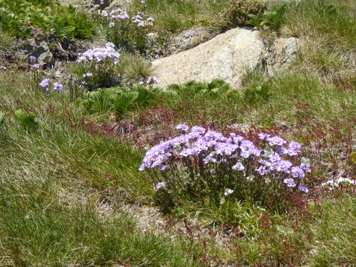
The gully down from the top was all snow grass and flowers
I backtracked my way to North Ramshead, but instead of heading back down to the grid walkway I stayed up on the ridge and headed towards the top of Karel's T-Bar. Along the way you will have to cross the creek, and I fount that it was easiest higher up. Further down the valley it got very rocky. The area between North Ramshead and the top of Karel's is full of inspiring rock formations, representing all sorts of creatures (well, to me anyway).

I went around North Ramshead to the right and stayed on the ridge.
Father and Son
Tortoise

Man wearing beret

Big Frog

Most of the walk can be done on snow grass. There are a few wet areas to cross, and here you just need to take care to use rocks or snow grass pads, rather than trampling the bog, which is very fragile. I found it quite easy going and the whole tour only took me about 3 1/2 hours.

Tread lightly through the wet areas

Top of Karel's T-Bar. It may look like a heritage museum, but
it is actually still in use.