I took the coastal road south from Margaret River. It took me trough large forests, not just large in area, but also in the height of trees. The further south I got the larger the trees seemed to grow. I took a short break at Hamelin Bay, which is a sanctuary for rays and people in Margaret River told me that you can hand feed them next to the boat ramp. Well, there weren't any rays about when I was there. Never mind, it was a nice spot to visit anyway with a beautiful sandy beach.
 |
| Hamelin Bay, south of Margaret River |
From Hamelin Bay I drove an hour and a half to get to Pemberton, where you are allowed to climb some of the large trees. They have been used as fire lookouts and the way to climb them is via a set of spikes that spiral around the tree and take you up to the viewing platform in a more or less vertical climb. I had every intention of climbing the Gloucester Tree, which is closest to town, but once I got there and saw the spikes I chickened out. I would have been OK if I was by myself, but there was a steady stream of people and I just couldn't face crossing anyone on the way up or down. So all I can report to you is that no-one ever died from falling (apparently some died from heart attacks after getting back down) and that the platform is 52 metres above ground. I can't tell you whether the view is worth the climb.
 |
| The climbing spikes up the Gloucester Tree in Pemberton |
From Pemberton the road took me through more forests to a place called Walpole on the South Coast. I had a coffee in one of the two local cafes and visited the tourist office to find out what the local attractions were. They sent me on a short drive out to a headland from where I could look over the inlet on which the town is situated and from there they sent me on to a place called Valley of the Giants, where you can take a tree top walk through a forest of very tall trees. After chickening out at tree climbing I thought that I owe it to you to report what a tree top walk looks like. Basically it started at ground level and led over steel suspension bridges up to a height of 40 metres over a valley full of red tingle trees. They grow up to 70 metres tall and are very impressive to look at, even from ground level. The tops look very much like any other gum tree, but being up there, looking down, gives you a better idea of the height.
 |
| The tree top walk in the Valley of Giants near Walpole |
From the valley of giants I drove on towards a town called Denmark. Just before the town there is a road marked William Bay that turns to the right of the main road. After about four kilometres you get to the bay and a couple of great swimming spots. One of them is called elephant rocks, where huge boulders shelter the swimmer from the force of the Indian Ocean. The second is Greens Pool, which is protected by a lower, but longer rock band. It was only 18 degrees, so I didn't feel much like swimming, but as usual there were some Germans in the water; they must be used to the temperatures from swimming in the North Sea.
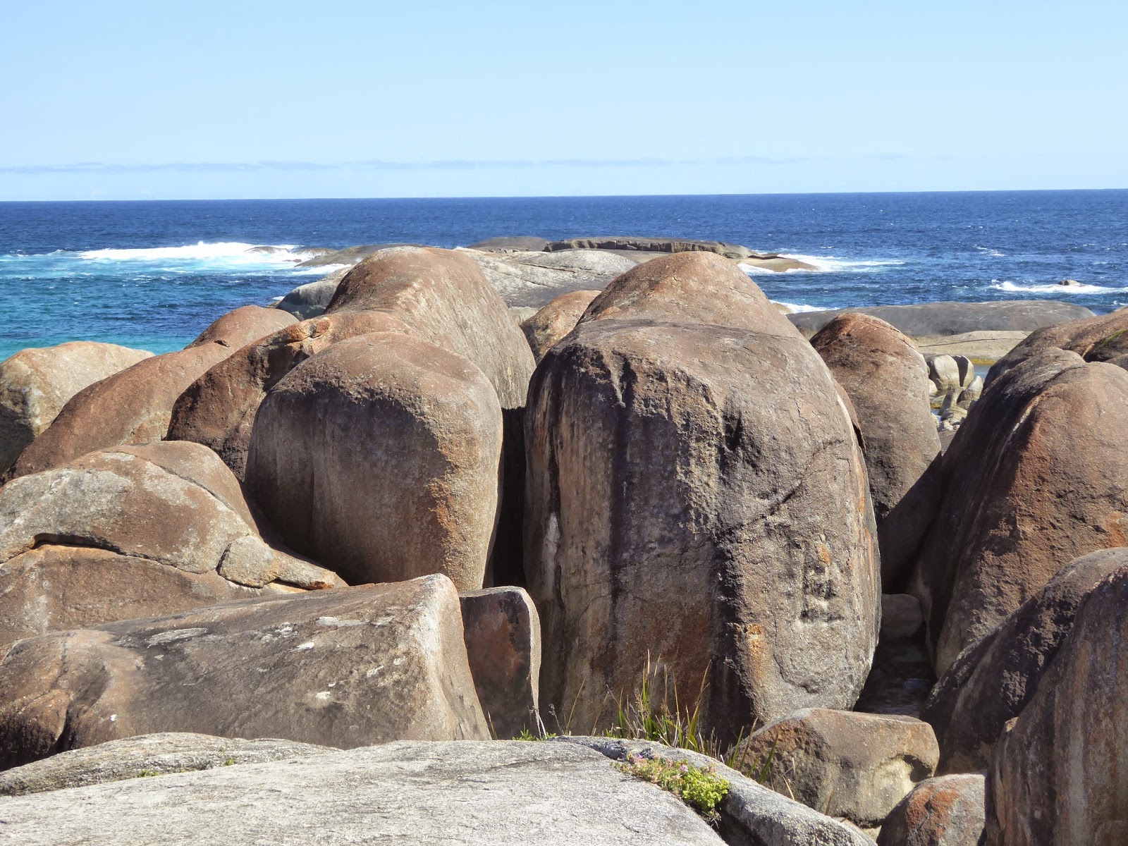 |
| Elephant Rocks |
 |
| Elephant Cove (below Elephant Rocks) |
 |
| Green's Pool |
I got to Albany at about five in the afternoon. I tried to go to the supermarket to buy some dinner, but all the large shopping centres were closed. In the end I found a local IGA shop in the old town centre that was open and could sell me some sustenance.
In the morning I got up and dropped off my car at the local 4x4 centre to get a bull bar fitted. I had a few too many close encounters with wildlife recently and thought I might add some extra protection before heading off across the Nullarbor. Of course this meant that I was carless for the day and had to visit local sights that were accessible on foot. I started the day by walking from the industrial estate into town and up to Mt Clarence, where all the war memorials are. I didn't know whether there were any paths up from where I was, so I headed in the general direction, past a school and into the bush along a dry creek bed. I was lucky and met a path after only about 200 metres. The path was marked as "Padre White Trail" and as I later learned, Padre White was the first priest in Australia to hold a dawn service on ANZAC day and took his congregation up to Mt Clarence to watch a wreath being thrown into the King Island Sound, from where the first two convoys of troop ships departed in 1914. The walk up Mt Clarence was actually quite pleasant. The day was overcast and there was a cool wind, ideal for walking up hill. On the summit there was a viewing platform and then a much more landscaped path down the other side, leading to the ANZAC Desert Corps Memorial. I may need to explain for my non-Australian friends that ANZAC stands for "Australian and New Zealand Army Corps" and refers to the troops that fought in the first world war on behalf of the British Empire, first at the Dardanelles and then on the Western Front in France and Belgium. The mateship and bravery that these troops displayed under the most extreme hardship and danger is seen as one of the defining moments in the history of the Australian Nation. Because the first troops left from Albany, there is a lot of emphasis on this episode of history and the whole of Mt. Clarence and its neighbour Mt Adelaide is dedicated to ANZAC memorials.
 |
The Desert Corps Memorial is a copy of the one that
stood in Port Said before it was destroyed during the Suez Crisis |
 |
The Lone Pine Memorial is grown from seeds in a pine cone
that were collected by soldiers in the Dardanelles |
I walked from Mt Clarence across to Mt Adelaide, where the new ANZAC Memorial Centre stands. Along the way there were signs with quotes from WWI soldiers and contemporaries that brought home the senselessness of the whole undertaking. Up on Mt Adelaide is not only the new memorial centre, but also a fortress that was used from the early to mid nineteen hundreds do defend the King George Sound from enemy attack. You can walk up to the top of Mt Adelaide along a straight road lined by pictures and data on all the ships that sailed in the first and second troop convoy, and then return along a track that leads through the old fortifications. Like any military history site it is a bit of a mix of "let's never do this again" and "lets show off our weaponry". At the end of the walk down to the memorial centre is a collection of torpedoes, missiles and gun turrets. Some of the anti-aircraft guns turrets can be turned and aimed, and children and adults alike seemed to have a lot of fun doing so.
 |
| Playing with guns is fun for all ages |
 |
| Gun with 8 km range to protect King George Sound |
The ANZAC Memorial Centre is brand new, it was opened on November 1 to commemorate the sailing of the first convoy one hundred years ago. It is not very big, but packed full of information, delivered through multi-media displays. When you buy your ticket you are given a small card with the name and picture of a WWI soldier. You can then place this card onto readers in the different areas of the centre and it gives you the records of your particular person in any given context of the first world war, thereby making the whole history much more personal. I spent almost two hours going through the centre. I then headed down the hill towards the port of Albany and turned right along a coastal walk to Middleton, which is where I stayed. There were snake warning signs along the walk but all I saw were dozens of King Skinks, which grow to about 40 cm in length. Later in the afternoon I walked back to pick up the car and was surprised to find that I walked just over 27,000 steps that day, according to my iPhone.
 |
| Lots of Skinks along the way |
 |
| Middleton Beach, where I stayed, about 3 km walk from the centre of Albany |
 |
| New bull bar on my trusty vehicle |
The next morning I took the car and drove along the foreshore around Princess Royal Harbour, which is the name of the bay on which Albany is situated. On the other side of the bay is Torndirrup National Park, which encompasses the coast facing the Indian Ocean to the South, as well as Bald Head, which is the headland that protects King George Sound from the open sea. There is a 16 km walk out to Bald Head, but the day was miserable with heavy thunderstorms, so I didn't want to risk a ridge walk along slippery rocks. I did walk up to Isthmus Hill during a break in the weather, which is the first 2 km of the walk and has some good views over the peninsula. But first things first: when I read the tourist map there was a "historic whaling station" marked as one of the attractions in the National Park, so I thought I'd go and check it out, I do like historic sites. When I got there I saw a factory ahead of me and was disappointed that they would allow industry so close to a historic site. Little did I know that this factory actually was the historic site. The whaling station operated from 1952 to 1978 and when it shut down it was preserved completely intact as a whaling museum, and that includes a complete whaling ship, called a whaling chaser.
 |
| The "factory" at the historic site |
I forked out $29 for the entrance fee and first of all spent about half an hour crawling all over the whaling chaser. You can go into all the cabins, galley, engine room, chart room etc. getting a really good idea of what life on this ships would have been like. In the mess they play a video of how the whales were chased and harpooned. They basically shot them, killed them, fitted a radio beacon onto them, pumped some air into them and let them drift for later collection. After a day's work they would then collect the dead whales and tow anything up to 14 of them back to the whaling station where they tied them up to pontoons for later processing. In the beginning they hunted humpback whales, and when they got protected in the sixties they changed over to sperm whales. They had a quota of 1000 whales per year. With a total workforce of 120 people this allowed them to produce an annual profit of just over 2 million dollars per year. The reason they stopped in 1978 was because the crude oil that they used to generate the steam for their engines got too expensive and ate away all the profit.
 |
| Whaling chaser |
On the full hour they had guided tours through the rest of the station. The tour started on the flencing deck, where they dragged the whales from the sea and cut them up into big strips. From there the strips were pulled onto the cutting up deck, where they were cut into smaller bits that fit the boilers, which were used to render the oil. But it was not just the oil that they sold, they also sold the teeth of the sperm whale for ivory and turned the rest of the meat and bones into whale meal, which was used as a protein additive for cattle feed. So the whole whale was made use of. There were pictures of the whole process - a lot of blood and gore, and apparently the stench was unbelievable. The tour ended with a visit to the old oil storage tanks, which now house a move theatre in each, showing three different short movies about whaling, whale protection and shark protection. The whole thing was a bit reminiscent of the war memorial on the previous day in that it glorified the toughness of the job on the one hand, and telling what a bad thing it was on the other.
 |
| A steam driven saw to cut up whale heads |
 |
| Whales waiting to be processed, tied up to a pontoon (old picture) |
 |
| The oil tanks, which now house a movie theatre in each |
I spent about 2 1/2 hours at the museum and by then the weather had cleared up a little, so I visited all the natural attractions that were marked on the national park map. They were all different spots along the ocean side of the peninsula, where the forces of the sea have carved out some pretty and some spectacular sites. One attraction was a set of blow holes, where the swell pushes air and water through underground caves that then release their spray up onto the rocks. Unfortunately the swell wasn't big enough to blow any spray, so all I got was very noisy air blowing up, which was hard to photograph.
 |
| Not so blowy that day... |
Aside from walking up to Isthmus Hill I took a shorter walk on top of Stoney Hill, with views across to Albany, then drove on to Jimmy Newell's Harbour and finally to The Gap and The Natural Bridge. All of them were worthwhile looking at and it took me into mid-afternoon to get it all done.
 |
Looking towards Albany from Stoney Hill, left of the spit
is Princess Royal Harbour, right is King George Sound. The mountain
in the distance is Mt.Clarence where the ANZAC memorial is |
 |
| Jimmy Newell's Harbour |
 |
| 25 metre high cliff at The Gap |
 |
| The Natural Bridge |
On the way back into town I stopped off at a replica of the brig Amity. The Amity brought the first convicts and settlers from Sydney to Albany in 1826 to establish a colony. The replica is open for visits and you can take a self-guided audio tour through the decks, cargo hold and officers quarters. The brig stands in a pond directly below the first town site, and only a short stroll from the town centre of Albany, York Street, which I found quite pretty in itself.
 |
| The brig Amity |
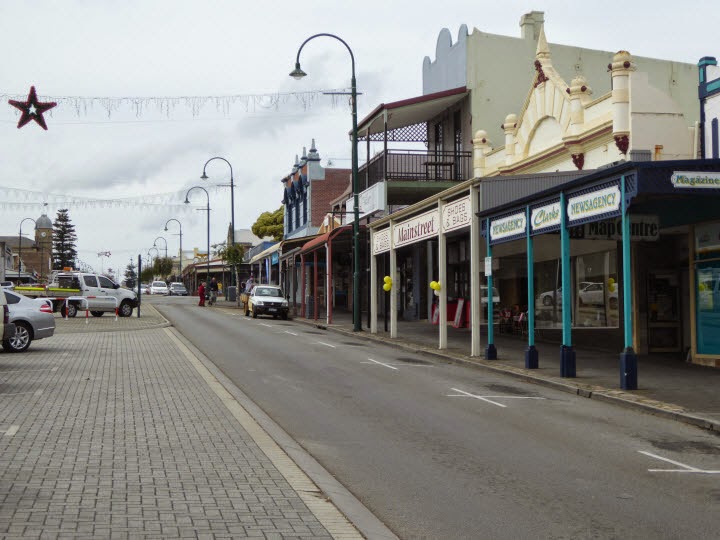 |
| York Street Albany |
Albany was my last multi-night stay in WA. From here I will travel east towards the Nullarbor, with overnight stops at Esperance and Norseman.


